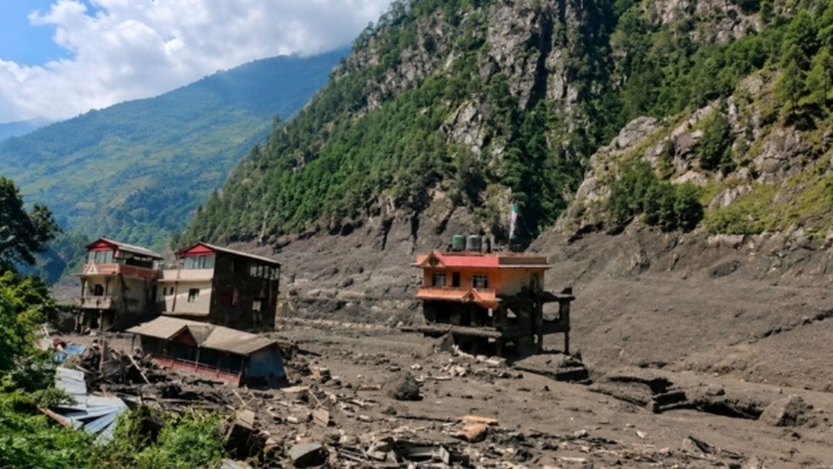
The first footage out of Nepal’s August 26 disaster barely made sense. There’d been no big rainstorm beforehand, nothing that would explain a quiet Himalayan river suddenly transforming into a violent, brown, boulder-choked torrent.
Downstream, water levels shot up by several metres in minutes, then dropped just as fast once the main surge rolled past.
Scientists have since pieced together a much clearer, and far more unsettling, picture of what actually happened.
At a Glance:
- August 26 disaster began with a glacier/rock collapse near Langtang Lirung, roughly 5,200 metres up
- The mass fell about 1,200 metres, smashed into the Lhende Khola river, and temporarily dammed it
- When that natural dam gave way, a debris-choked surge tore downstreamTrishuli River at Galchhi rose nine metres in just 30 minutes
- No heavy rainfall preceded the disaster, ruling out a normal monsoon flood
- Scientists are calling it a “hazard cascade,” not a straightforward GLOF (glacial lake outburst flood)
- Climate change likely plays a role in destabilising high-mountain terrain, but no direct causal link has been confirmed yet
It started with a mountain failing, not a storm
The trigger wasn’t rain. Nepal’s Department of Hydrology and Meteorology confirmed there had been no significant rainfall over the Rasuwa area right before the disaster hit, a detail that matters enormously, since people living along Himalayan rivers usually read a sudden rise as a sign of heavy rain further upstream. This time, the mountain itself gave way.
Satellite imagery taken before and after the event shows a large chunk of glacier near Langtang Lirung had simply broken off. Reuters’ own satellite reconstruction places the failure at somewhere between 5,127 and 5,200 metres, with the detached mass plunging roughly 1,200 metres into the valley below. Cloud cover and dust initially blurred the early images, but clearer shots later revealed something more complicated than a simple glacier break.
Geomorphologists Kristen Cook and Dan Shugar found signs the collapse wasn’t limited to ice alone. “It looked like there was not only this glacier that had failed, but a much larger chunk of the bedrock,” Shugar told the Associated Press. The material didn’t just fall and stop either.
Cook noted the debris kept its momentum well after hitting the valley floor, and as it barrelled through the steep, narrow terrain, the ice began melting, mixing violently with water and loose sediment along the way.
Simon Cox, chief scientist of the Mountains to Sea programme at Earth Sciences New Zealand, described roughly the same sequence: material falling from 5,200 metres into a valley 1,200 metres below, then bulking up into a massive debris flow as it absorbed water and sediment on its way down. Worth being precise here, this wasn’t glacier “melting.” Melting is slow, gradual. What happened on August 26 was sudden mechanical failure, a huge mass of ice and rock losing stability all at once, falling fast, and setting off a chain of destructive events in sequence.
The river got blocked, then the blockage became the real disaster
Once the mountainside collapsed, the second, arguably more dangerous, phase began. Satellite evidence suggests the avalanche crashed into the Lhende Khola and temporarily dammed it. ICIMOD flagged an ice avalanche as the likely trigger, while researchers in Nepal and China kept digging into the exact chain of events.
The physics here are brutally simple. A river normally flows continuously, water comes in from upstream and keeps moving down. Drop a massive pile of rock, ice and debris across that channel, and the whole system breaks. Water starts backing up behind the blockage, essentially forming a makeshift, unengineered dam, one with none of the structural integrity or controlled outflow of an actual reservoir. As pressure builds, it grows increasingly unstable, until water eventually forces its way through or around the obstruction.
Once that breach starts, it snowballs. Erosion widens the gap, more water rushes out, more material gets torn loose, and the whole release accelerates rapidly.
Rijan Bhakta Kayastha, a professor at Kathmandu University and climate researcher, put it plainly: “This was not a regular flood.” That single observation captures why this disaster involved multiple overlapping processes rather than one clean, easily-labeled mechanism. A group of international glacier researchers has said a glacial collapse was almost certainly involved, but likely wasn’t the sole cause. Andrew Mackintosh, a glaciologist at Monash University, suggested the failure may have been the glacier alone, or a much bigger mountainside collapse that simply included part of the glacier within it.
“When a glacier of that scale collapses, it generates a lot of water,” Mackintosh said, describing how water and sediment combine and pile up as the flood builds.
The flood grew as it travelled:
- Ice melted
- Sediment got swept up
- Riverbanks eroded away
- Boulders and debris got pulled straight into the flow
- The valley itself effectively became part of the flood.
Why did the river jump nine metres in half an hour?
This is the part that looks almost fake in the videos. A river looking totally ordinary one moment, then turning enormous within minutes. The explanation: this wasn’t a slow, rainfall-driven rise stretched evenly across many hours. It behaved like a violent pulse ripping through a steep river system.
ICIMOD reported the Trishuli at Galchhi rose as much as nine metres in just 30 minutes. At Malekhu, it climbed roughly seven metres over a similar window, an extraordinary shift in an incredibly short span of time.
Jon Tunnicliffe, an associate professor of river science at the University of Auckland, called this a “hazard cascade.” His explanation runs like this: instability high up on a glacierised slope turns into an ice-rock avalanche, that avalanche blocks a river, the blockage sucks in water and sediment, and the whole thing eventually transforms into a debris-choked flood barrelling tens of kilometres downstream. He added a blunt warning: “A localized failure at more than 5,000 meters can very rapidly become a catastrophe for people far down the valley.”
Himalayan geography makes all of this worse. Upper river valleys are steep, narrow, with almost no room for a sudden mass of water and debris to spread sideways. Gravity just keeps dragging everything downhill while the valley walls squeeze it into a single, concentrated path. Reuters reported the debris flow may have hit speeds of around 50 metres per second, roughly 180 kilometres an hour, and stretched more than 20 kilometres, according to Chinese government geologist Guo Zhaocheng.
At that kind of speed, calling it a “flood” almost undersells what it actually is to anyone caught in its path, it’s closer to a moving wall of debris. That speed also explains the razor-thin warning window. Someone might notice the river starting to rise only shortly before the main surge actually arrives, there’s no gradual, hours-long buildup that would give a community time to organise an evacuation. And once the main pulse passes, water levels drop fast too, simply because that extraordinary surge has already moved on downstream. Hence the seemingly impossible sequence caught on video: ordinary river, sudden wall of water, destruction, then a rapid drop. The flood didn’t vanish. It just moved on.
Was this a glacial lake outburst flood, and did climate change cause it?
The sheer volume of water flowing out initially fuelled speculation this was a glacial lake outburst flood (GLOF), which happens when water stored in a high-altitude glacial lake suddenly releases after a natural dam fails. Nepal has been here before, including a major flood in this same broader river system back in July 2025.
But scientists are being careful about slapping the GLOF label onto this specific event. Nature reported that satellite imagery from before the collapse showed no major lake existing at the site, evidence instead points to the avalanche itself blocking the Lhende Khola and creating a temporary body of water only after the collapse happened. So the actual sequence likely runs: glacier and rock -collapse river blockage temporary water -buildup sudden release debris-heavy flood. That’s meaningfully different from a pre-existing glacial lake just suddenly emptying out, and it matters because it shows how many different hazards a single high-mountain landscape can generate: avalanches, landslides, GLOFs, river blockages, debris flows, each one capable of triggering the next.
Climate change is part of this story too, though scientists are careful not to name it as the direct, immediate cause. Simon Cox said the broader warming trend matters regardless: “Climate change is generating conditions that can destabilise high-mountain rock and ice.”
The mechanism isn’t as simple as warmer temperatures melting a glacier until it falls, warming reshapes multiple parts of the mountain system simultaneously. Glaciers lose mass. Snow patterns shift. Freeze-thaw cycles change. Permafrost, permanently frozen ground that helps hold rock together, degrades. All of that can leave steep slopes considerably more vulnerable to collapse.
Alton Byers, a mountain geographer at the University of Colorado Boulder, said the event carried clear signs of a warming environment, pointing specifically to weakening permafrost as a genuine concern. But Cook cautioned against jumping to a direct climate link before the evidence is fully in:
“While we cannot at this point directly link this collapse to climate change, it is not unexpected to see more events of this type with a warming climate.” Mackintosh drew a similar line, scientists have strong evidence connecting glacier retreat to climate change broadly, but too few large glacier collapses have actually been documented to establish a clear, direct relationship between warming and this specific type of failure.
The evidence supports a warming Himalaya becoming more exposed to unstable ice, rock and permafrost. It doesn’t yet prove climate change directly pulled this particular mountainside down on August 26.
The hardest problem isn’t understanding the flood, it’s warning people before it happens
Scientists can reconstruct most of what happened using satellite images, seismic records, river gauges and video footage after the fact. Predicting it beforehand is a completely different, much harder problem. The glacier involved sat at roughly 5,200 metres, in remote, difficult terrain that limits conventional monitoring. Clouds routinely block satellite observation. Glaciers can change rapidly, and a rock or ice failure can happen without any of the rainfall signals that normally trigger flood warnings.
Alton Byers didn’t sugarcoat it: “You can’t predict these events.” That doesn’t mean nothing can be done though, it means warning systems need to look well beyond rainfall data. Tunnicliffe argues mountain countries increasingly need to manage entire hazard chains rather than treating each individual hazard in isolation, satellite monitoring of glaciers, lakes and slopes needs to work in tandem with seismic sensors, river gauges and warning systems capable of catching a cascade the moment it begins.
Those first few minutes might matter more than anything else. A seismic station can pick up a major collapse almost instantly. A river gauge downstream can flag an abnormal surge in real time. Cameras can confirm what’s actually unfolding. Automated systems can push out warnings before any human operator has time to sift through every piece of incoming data.
The problem gets even harder because this river system crosses an international border. The collapse happened in a high Himalayan zone linked to Tibet and Nepal, while the destructive flow travelled deep into Nepalese territory. ICIMOD has called for stronger regional cooperation, simply because the hazard itself doesn’t stop at a national boundary. Mohd. Farooq Azam, a senior cryosphere specialist at ICIMOD, summed up the broader challenge:
“The pace of change is so rapid that current efforts are struggling to keep up. “That might be the most practical takeaway from Nepal’s disaster. Predicting every single collapse perfectly may simply never be possible. The real task is shrinking the gap between a collapse happening and people downstream actually knowing something catastrophic is barrelling toward them.
August 26 laid that lesson out in brutal detail:
- A mountain can fail at 5,000 metres
- A river can be blocked within seconds
- A temporary reservoir can form without anyone even seeing it happen
- That blockage can fail
- Water, ice, rock and mud can then travel tens of kilometres through a narrow valley
- By the time the flood reaches a settlement, the event that caused it may already be many kilometres upstream
Nepal’s disaster response teams are now working to assess damage across the affected river corridor, while ICIMOD and international researchers continue studying satellite and seismic data from the collapse to refine how similar events might be detected earlier in future.